
The Bora-Bora island
country : French Polynesia
place : in the middle of the Pacific
 Your really do deserve a vacation to Bora Bora. Don't fight it, you know it's true...
Bora Bora island is possibly the single most famous island in all the world. The legends, mysteries, and romance associated with the words "Bora Bora" bring an almost mystical presence to the island.
It's true Bora Bora is indeed a wonderful place to vacation... but this magical presence is not so unattainable.
Facts from the fiction regarding this wonderful Tahiti Polynesian island paradise: Tourism aspects, activities, practicalities, culture, and all the things you'll want to know when planning a trip to Bora Bora. We propose to the would be traveler that the Island of Bora Bora is quite real and attainable as a vacation getaway.
 Part of the allure has to be its almost unbelievable beauty. Two towering peaks of sheer black rock dominate the center of the island and make an impressive backdrop to an assortment of blue waters that will dazzle the eyes.
Bora Bora's lagoon is its most treasured feature, and allows the traveler many opportunities to experience it in a variety of ways. Windsurf, jetski, scuba dive, snorkel, swim, bask in its warmth... the list goes on.
Bora bora is truly an experience worth having. A wonderfully relaxing place to be as well as a great island for you to experience, your Bora Bora vacation will never be forgotten.
Bora Bora, The Romantic Island
Under a one hour flight from the island of Tahiti or Moorea, the island of Bora Bora, with a lagoon resembling an artist's palette of blues and greens, is love at first sight.Romantics from around the world have laid claim to this island where the castle-like Mount Otemanu pierces the sky. Lush tropical slopes and valleys blossom with hibiscus, while palm-covered motu circle the illuminated lagoon like a delicate necklace. Perfect white-sand beaches give way to emerald waters where colored fish animate the coral gardens as they greet the giant manta rays. This could be easily be described as the center of the romantic universe, where luxury resorts and spas dot the island with overwater bungalows, thatchedroof villas, and fabled ambience.
Simply said, Bora Bora is the most beautiful island in the world.
 Pora Pora - the ancient name, meaning "first born," came from legends describing this as the first island to rise when Taaroa,
the supreme god, fished it out of the waters after the mythical creation of Havai'i, now known as Raiatea. Although the first letter "B" does not exist in the Tahitian language, when Captain Cook first heard the name he mistook the softened sound of the Tahitian "P" for "B" and called the island Bola Bola.
Romance on Bora Bora
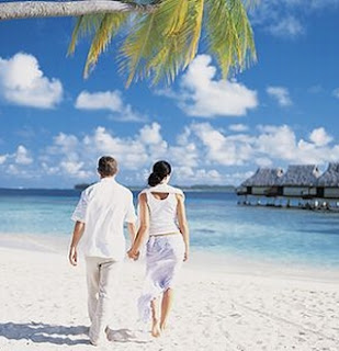
Truly, the most romantic island in the world. From the dramatic scenery to the privacy and amenities of the overwater bungalows, everything in Bora Bora equals a 10 on the romance scale. Resorts have been welcoming couples for over 40 years and their special amenities have been fine tuned to perfection. From sunrise to sunset, each resort has designed their own blend of unique romantic experiences for their guests to choose from.
 For The Visitor, The Majesty of Bora Bora offers:
Enchantment from the neon-lit turquoise lagoon waters with unending days of exploration through snorkeling and diving.
Excitement above the lagoon by outrigger canoe, Boston Whaler, wave runner, jet ski, and dramatic sunset cruises aboard a catamaran sailboat.
Exploration of the panoramic overlooks found by hike or 4x4 accompanied by entertaining local guides.
Discovery of the world-renowned shopping for local and international original art, Tahitian pearls, perfumes and oils, and precious wood handcrafts.
The turquoise water of the lagoons, an exhilarating ride over it by canoes, jet ski or a catamaran sailboat, a sunset view that takes your breath away, cruising along the panoramic views, a vibrant marine life that you can come close to by snorkeling and diving and the souvenir shops that allow you take home the memoirs from here, in short, this is the much acclaimed Bora Bora Island.
The name Bora Bora comes from the Tahitian word Pora Pora, which means “first born”. Legends describe it as the first island to rise when the Supreme God Taaroa fished it out of the waters after the creation of Havai’i. When Captain Cook heard the name, he mistook Pora Pora for Bora Bora and that’s how the name gained currency and is used till date.
As per an early transcription found in 18th and the 19th century accounts, the name of the Island is recorded as Balobolla or Bollabolla.
 Location
The Bora Bora Island belongs to the Leeward group of the Society Islands Archipelago of French Polynesia, in the South Pacific Ocean. The Island, stretching to about 18 miles, is surrounded by a lagoon and a barrier reef.
When to go
The Bora Bora Island has a tropical climate that favours tourism all through the year. The Polynesian summer is the wet season here, in the months from November to March. The months of February and March are the hottest months which also record a high amount of rainfall. The Polynesian winter or the dry season comes in the months from May to October.
The dry season is also the peak tourist season here with a number of tourists coming in at that time.
How to go
The Island of Bora Bora has a small airport on the Motu Mute. The airstrip at Motu Mute was built during the World War II, by US marines as a refueling stop on the America to Australia supply line.
You need to take a connecting one hour flight from Papeete in Tahiti Island to get here. Papeete is about 8 hours away by flight from Los Angeles.
Air Tahiti serves a 20 minute flight to Tahiti from Huahine and Raiatea, has regular flights to the Tuamotu Atolls as well as weekly flights to the Marquesas.
From the Motu Mute airstrip, you need to take a short ferry trip to get to the village of Vaitape and then take a shuttle or other means of transport to explore the Island.
While in the Bora Bora Island, you can ask your hotel to arrange a shuttle service for you or you can rent a car, scooter or a bicycle to explore the Island at your own leisure. These rental services are available at the Vaitape Village.
 Attractions of Bora Bora Island
The Bora Bora Island is not just a scenic beauty. The Island offers a number of thrilling activities that you can enjoy.
The hotels here can make arrangements for fishing, diving, water skiing, sailing, canoeing, cruising or snorkeling and other water sports of your choice. You can paddle you way on kayaks to the lagoon. You can also opt for cruises.
There are jet tours that you can take for an excursion to the lagoons here and also explore the inland areas through an organized tour.
Snorkeling and diving can give you the joy of swimming with marine life like manta rays, eagle rays, sharks and over one thousand species of tropical fishes in the lagoon of the Bora Bora Island.
Some of the popular snorkeling and diving sites are over the coral gardens in and around the Bora Bora Lagoonarium and the Anau – a site between the former site and Point Haamaire. The lagoon off the eastern side of Motu Toopua and the islet nest to it, the Motu Toopua Iti too are good sites fro both snorkeling and diving.
Off Motu Tapu, the islet south of Teavanui Pass, is the most easily accessible site for diving in the Bora Bora Island. At some distance that can be covered by lengthy boat rides are two more dive site, the White Valley, off the airport and Tupitipiti, to the south east corner on the reef. They are however, meant for expert divers as they can experience strong currents.
The “Aquarium”, a snorkeling site off the southern end of Motu Pitiaau and around Motu Piti Uuuta, is one of the best snorkeling sites of the Bora Bora Island. To reach here, you would need to ride there by boat, or you can walk to the outer reef from the southern tip of Point Matira. Flying Underwater here too is a good snorkeling spot.
 You can also go for night dives.
Shopping too can be fun here. The shops here are well known with souvenirs like local and international original art, Tahitian pearls and handicrafts made of wood.
If you are not comfortable diving or snorkeling, or even other wise, you can enjoy the view of coral and schools of tropical fish through a glass bottom boat. Motor boats give you a fast paced way to explore the lagoon.
If you want, you can enjoy the Shark and Ray feeding tours as well as you snorkel.
Going to Motu Tapu, a small islet about a few hundreds yard away form the Island of Bora Bora is just ideal if you want to relax in a secluded surrounding.
Another major attraction of this French Polynesian Island is the Matira Beach, one of the world’s most popular beaches.
There are guided hikes to Mount Pahia and Mount Otemanu, remnants of two extinct volcanoes in the center of the Island, too that you can go for. The Mount Otemanu is the highest point here, measuring about 727 meters. Along the coast are ancient marae temples that are worth a visit.
The ambience of this South Pacific Island of Bora Bora creates a mood that is simply romantic, something that you dream of. The white sandy beaches, the turquoise water of the ocean, the lush green tropical slopes and the rich and vibrant, colourful marine life makes the place look like an artists imagination that has come live from a canvas. The Bora Bora Island is certainly a place you should visit once in your life time.
Source:
www.boraboraisland.com
http://www.tahiti-tourisme.com
http://www.theearthtraveler.com
Read More »»
country : French Polynesia
place : in the middle of the Pacific

Bora Bora island is possibly the single most famous island in all the world. The legends, mysteries, and romance associated with the words "Bora Bora" bring an almost mystical presence to the island.
It's true Bora Bora is indeed a wonderful place to vacation... but this magical presence is not so unattainable.
Facts from the fiction regarding this wonderful Tahiti Polynesian island paradise: Tourism aspects, activities, practicalities, culture, and all the things you'll want to know when planning a trip to Bora Bora. We propose to the would be traveler that the Island of Bora Bora is quite real and attainable as a vacation getaway.

Bora Bora's lagoon is its most treasured feature, and allows the traveler many opportunities to experience it in a variety of ways. Windsurf, jetski, scuba dive, snorkel, swim, bask in its warmth... the list goes on.
Bora bora is truly an experience worth having. A wonderfully relaxing place to be as well as a great island for you to experience, your Bora Bora vacation will never be forgotten.
Bora Bora, The Romantic Island
Under a one hour flight from the island of Tahiti or Moorea, the island of Bora Bora, with a lagoon resembling an artist's palette of blues and greens, is love at first sight.Romantics from around the world have laid claim to this island where the castle-like Mount Otemanu pierces the sky. Lush tropical slopes and valleys blossom with hibiscus, while palm-covered motu circle the illuminated lagoon like a delicate necklace. Perfect white-sand beaches give way to emerald waters where colored fish animate the coral gardens as they greet the giant manta rays. This could be easily be described as the center of the romantic universe, where luxury resorts and spas dot the island with overwater bungalows, thatchedroof villas, and fabled ambience.
Simply said, Bora Bora is the most beautiful island in the world.

the supreme god, fished it out of the waters after the mythical creation of Havai'i, now known as Raiatea. Although the first letter "B" does not exist in the Tahitian language, when Captain Cook first heard the name he mistook the softened sound of the Tahitian "P" for "B" and called the island Bola Bola.
Romance on Bora Bora
Truly, the most romantic island in the world. From the dramatic scenery to the privacy and amenities of the overwater bungalows, everything in Bora Bora equals a 10 on the romance scale. Resorts have been welcoming couples for over 40 years and their special amenities have been fine tuned to perfection. From sunrise to sunset, each resort has designed their own blend of unique romantic experiences for their guests to choose from.

Enchantment from the neon-lit turquoise lagoon waters with unending days of exploration through snorkeling and diving.
Excitement above the lagoon by outrigger canoe, Boston Whaler, wave runner, jet ski, and dramatic sunset cruises aboard a catamaran sailboat.
Exploration of the panoramic overlooks found by hike or 4x4 accompanied by entertaining local guides.
Discovery of the world-renowned shopping for local and international original art, Tahitian pearls, perfumes and oils, and precious wood handcrafts.
The turquoise water of the lagoons, an exhilarating ride over it by canoes, jet ski or a catamaran sailboat, a sunset view that takes your breath away, cruising along the panoramic views, a vibrant marine life that you can come close to by snorkeling and diving and the souvenir shops that allow you take home the memoirs from here, in short, this is the much acclaimed Bora Bora Island.
The name Bora Bora comes from the Tahitian word Pora Pora, which means “first born”. Legends describe it as the first island to rise when the Supreme God Taaroa fished it out of the waters after the creation of Havai’i. When Captain Cook heard the name, he mistook Pora Pora for Bora Bora and that’s how the name gained currency and is used till date.
As per an early transcription found in 18th and the 19th century accounts, the name of the Island is recorded as Balobolla or Bollabolla.

The Bora Bora Island belongs to the Leeward group of the Society Islands Archipelago of French Polynesia, in the South Pacific Ocean. The Island, stretching to about 18 miles, is surrounded by a lagoon and a barrier reef.
When to go
The Bora Bora Island has a tropical climate that favours tourism all through the year. The Polynesian summer is the wet season here, in the months from November to March. The months of February and March are the hottest months which also record a high amount of rainfall. The Polynesian winter or the dry season comes in the months from May to October.
The dry season is also the peak tourist season here with a number of tourists coming in at that time.
How to go
The Island of Bora Bora has a small airport on the Motu Mute. The airstrip at Motu Mute was built during the World War II, by US marines as a refueling stop on the America to Australia supply line.
You need to take a connecting one hour flight from Papeete in Tahiti Island to get here. Papeete is about 8 hours away by flight from Los Angeles.
Air Tahiti serves a 20 minute flight to Tahiti from Huahine and Raiatea, has regular flights to the Tuamotu Atolls as well as weekly flights to the Marquesas.
From the Motu Mute airstrip, you need to take a short ferry trip to get to the village of Vaitape and then take a shuttle or other means of transport to explore the Island.
While in the Bora Bora Island, you can ask your hotel to arrange a shuttle service for you or you can rent a car, scooter or a bicycle to explore the Island at your own leisure. These rental services are available at the Vaitape Village.

The Bora Bora Island is not just a scenic beauty. The Island offers a number of thrilling activities that you can enjoy.
The hotels here can make arrangements for fishing, diving, water skiing, sailing, canoeing, cruising or snorkeling and other water sports of your choice. You can paddle you way on kayaks to the lagoon. You can also opt for cruises.
There are jet tours that you can take for an excursion to the lagoons here and also explore the inland areas through an organized tour.
Snorkeling and diving can give you the joy of swimming with marine life like manta rays, eagle rays, sharks and over one thousand species of tropical fishes in the lagoon of the Bora Bora Island.
Some of the popular snorkeling and diving sites are over the coral gardens in and around the Bora Bora Lagoonarium and the Anau – a site between the former site and Point Haamaire. The lagoon off the eastern side of Motu Toopua and the islet nest to it, the Motu Toopua Iti too are good sites fro both snorkeling and diving.
Off Motu Tapu, the islet south of Teavanui Pass, is the most easily accessible site for diving in the Bora Bora Island. At some distance that can be covered by lengthy boat rides are two more dive site, the White Valley, off the airport and Tupitipiti, to the south east corner on the reef. They are however, meant for expert divers as they can experience strong currents.
The “Aquarium”, a snorkeling site off the southern end of Motu Pitiaau and around Motu Piti Uuuta, is one of the best snorkeling sites of the Bora Bora Island. To reach here, you would need to ride there by boat, or you can walk to the outer reef from the southern tip of Point Matira. Flying Underwater here too is a good snorkeling spot.

Shopping too can be fun here. The shops here are well known with souvenirs like local and international original art, Tahitian pearls and handicrafts made of wood.
If you are not comfortable diving or snorkeling, or even other wise, you can enjoy the view of coral and schools of tropical fish through a glass bottom boat. Motor boats give you a fast paced way to explore the lagoon.
If you want, you can enjoy the Shark and Ray feeding tours as well as you snorkel.
Going to Motu Tapu, a small islet about a few hundreds yard away form the Island of Bora Bora is just ideal if you want to relax in a secluded surrounding.
Another major attraction of this French Polynesian Island is the Matira Beach, one of the world’s most popular beaches.
There are guided hikes to Mount Pahia and Mount Otemanu, remnants of two extinct volcanoes in the center of the Island, too that you can go for. The Mount Otemanu is the highest point here, measuring about 727 meters. Along the coast are ancient marae temples that are worth a visit.
The ambience of this South Pacific Island of Bora Bora creates a mood that is simply romantic, something that you dream of. The white sandy beaches, the turquoise water of the ocean, the lush green tropical slopes and the rich and vibrant, colourful marine life makes the place look like an artists imagination that has come live from a canvas. The Bora Bora Island is certainly a place you should visit once in your life time.
Source:
www.boraboraisland.com
http://www.tahiti-tourisme.com
http://www.theearthtraveler.com


